


If you're going out tonight, the National Weather Service advises you to bundle up. Delaware and Sullivan Counties are under a wind chill advisory from midnight Tuesday through mid-morning Wednesday. Temperatures are expected to drop to between zero and five degrees, with a wind chill factor of around 15 below zero, thanks to gusting winds:
The Wind Chill Is Expected To Be Cold Enough To Cause Frostbite In About 30 Minutes Or Less...And Could Lead To Hypothermia If Precautions Are Not Taken. Those Planning To Venture Outdoors Should Use Common Sense And Dress Warmly...Making Sure That All Exposed Skin Is Covered.
A special weather statement issued by the NWS in Albany, which covers Ulster, Greene and Schoharie Counties, says we can expect frigid temperatures through the end of the week:
Arctic Air Mass Will Result In Very Cold Temperatures This Week... An Arctic Air Mass Has Settled Across The Region And Will Persist For The Remainder Of This Week. Average High Temperatures Will Be In The Teens And Overnight Lows Dropping Back Into The Single Digits And Below Zero. In Addition...Westerly Winds With Gusts Over 20 Mph Will Result In Dangerous Wind Chill Readings Ranging From 15 Below Zero To 40 Below Zero.
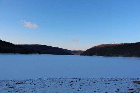
The photo above was taken just at dawn this morning at the Pepacton Reservoir, eerily calm in the crystal-clear January air. Photographer Greg Henderson describes the effect of intense cold on the Catskills landscape:
Pepacton Reservoir at 7:30am, January 22, 2013. 4 degrees outside. And today is supposed to be warm compared to most of the rest of the week. The coldness brings out a different kind of beauty in the mountains. A bluish/gray clarity. A feeling of enriched oxygen - purity entering your lungs as you inhale. We have not seen temperatures like this in several years. I never thought I would EVER say that I missed it, but there is something necessary about a cold streak in January. Welcome back, cold.


