


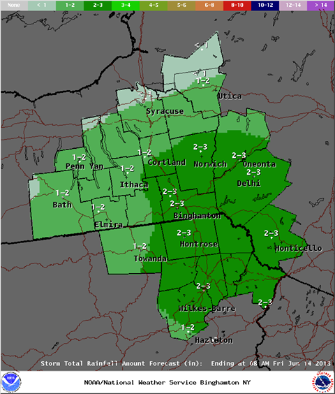
A rainfall prediction issued by the National Weather Service in Binghamton early Thursday morning, calling for 2 to 3 inches of rain in the southwestern Catskills region.
The latest forecasts for a rainstorm sweeping through the area Thursday and into Friday are calling for slightly less rain than originally predicted in some areas, but flood watches remain in effect throughout the Catskills region.
As the rainstorm has moved into the area from the southwest, it has tracked slightly more south than initially expected, Hudson Valley Weather reported late Wednesday night:
Storm looks to be taking a more southerly track and also a bit weaker as well. While the HV is still under the gun for a 1-3 inch rainfall the 4-5 inches looks a bit less likely. While the 2-3 is still enough to cause some issues with flooding it is a better solution. If the storm trends any further south we may see another reduction is projected rainfall.
Flood forecasts for major rivers and creeks in Ulster County have gone down slightly since Wednesday, reports Ulster County Emergency Services:
The overnight model guidance produced by the Storm Prediction Center and the River Forecast Center have down played the extent of flooding. We are still under a flood watch, and following is a look at the specific streams of interest in Ulster County:
- Lower Esopus - now forecast to remain in "action" stage, and not reach "minor" flood stage (a decrease of several feet from yesterday)
- Rondout - now forecast to only reach "minor" flood stage (a slight decrease from yesterday)
- Upper Esopus - still forecast to remain in "action" stage, and not reach "minor" flood stage
- Wallkill River - forecast to peak just short of "moderate" flood stage (another slight decrease)
A flood watch issued by the National Weather Service for eastern New York, including Ulster, Greene and Schoharie counties, is currently calling for one to three inches of rain across the region, with the heaviest rain falling in the southeastern Catskills.
Flooding is still a concern across the region, both from flash flooding on already-saturated ground and from rising creeks. In Delaware and Sullivan counties, the forecast has remained relatively steady. NWS flood watches are in effect for Sullivan and Delaware counties, with one and a half to two and a half inches of rain predicted.
Sullivan County Emergency Services issued a flood advisory this morning, and warns that widespread power outages could occur in the area.
Update (added 4pm): The New York City Department of Environmental Protection (DEP) has been releasing water from city reservoirs in an effort to mitigate downstream flooding since early last week, although flooding forecasts in creeks that receive releases have forced the agency to reduce some of its releases this week. In the case of the Schoharie Reservoir, where there is a large ongoing construction project, two 250-million-gallon-a-day water release siphons that empty into the Schoharie Creek have been turned on continuously since May 25.
The current rainstorm is the third to hit the region in the span of a week, and the city's water system is more full than average for this time of year, holding 100.6 percent of its estimated storage capacity as of Thursday, June 13. (Normal level for this date is 98.5 percent.)
Several local schools are dismissing early today because of the storm. See below for school closures and other breaking weather news.


