


Other images: 5-Day track on – 3-Day track on – 3-Day track off – InteractiveNew! ![[Image of 5-day forecast and coastal areas under a warning or a watch]](http://www.nhc.noaa.gov/storm_graphics/AT18/refresh/AL1812W5_NL_sm2+gif/144711W5_NL_sm.gif)
Above: The five-day forecast for Hurricane Sandy from the National Hurricane Center. The NHC has also posted an interactive Google map tracking the hurricane's progress as it moves northward.
Hurricane Sandy, currently lashing Cuba and the Bahamas with heavy rain and 105-mile-per-hour winds, is looking increasingly likely to make landfall in the Northeastern U.S. early next week. The National Hurricane Center's best prediction shows Sandy making landfall sometime Tuesday morning, with the Catskills region squarely within the "cone of uncertainty" in which the center of the storm may travel.
With Sandy still four or five days away from a potential impact on upstate New York, there is still a good deal of uncertainty in the models, and it is possible that the storm could blow out to sea. But a scenario in which Sandy makes landfall in the Northeast is looking more and more likely as the storm gets closer. Meteorologist Eric Holthaus writes for the Wall Street Journal today:
Regardless of the exact landfall location on the East Coast, impacts will be felt from Florida to Maine. Nearly every single major weather model now shows the eventual “phasing,” or capture, of Hurricane Sandy by an intense polar airmass. The two primary medium-range forecast centers for the National Weather Service agree. The European ECMWF, generally considered one of the best weather models in the world, has shown this scenario consistently for the last five days.
This consensus gives me enough confidence to increase to two-out-of-three odds that Greater New York experiences significant impacts from this storm.
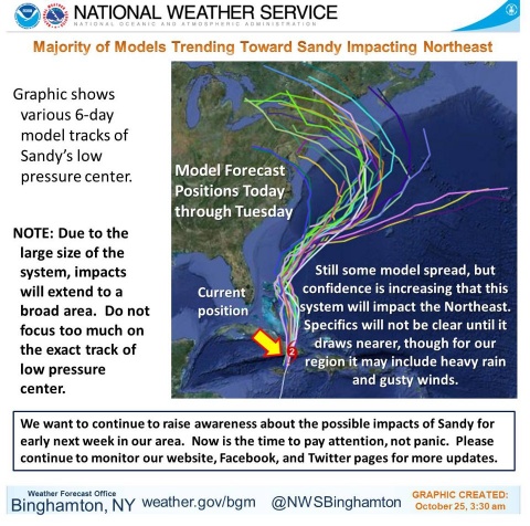
The National Weather Service at Binghamton has published a graphic on their Facebook page that illustrates the science pretty neatly: A map tracking the recent 6-day forecasts from different models. A few of the models show Sandy moving out to sea, but most of the models predict that Sandy will move inland:
The Watershed Post is currently making plans for covering Sandy's impact on the Catskills in real time. We'll keep you posted, and let you know how you can help. In the meantime, you can stay in touch with us on Facebook and Twitter, and please send us information about local storm preparations at editor@watershedpost.com.


