


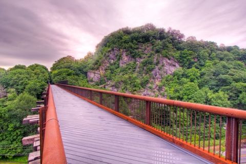
Above: The newly-restored Rosendale Trestle over the Rondout Creek, reopened in 2013 as a pedestrian walkway on the Wallkill Valley Rail Trail. Photo by John Fischer Photography (noroadunturned.com).
To celebrate National Trails Day, which is this Saturday, June 7, we're posting our article about new trails from our brand-new 2014 Catskills Outdoor Guide, which hit the streets on Memorial Day weekend. There are more new Catskills trails than we cover here -- stay tuned for more coverage about Catskills trail events later this week.
The saying “as old as the hills” is especially apt in the Catskills, a mountain range that stood as a high plateau more than 100 million years before the Rockies began to rise in the West. But across the time-worn mountains, new pathways are always springing up.
In recent years, the region has seen a spate of new trail-building activity, as local towns, nonprofits and business groups look for more ways to draw visitors up into the mountains. A growing volunteer trail-building effort is afoot, spearheaded by the New York-New Jersey Trail Confer- ence, whose members maintain over 200 miles of trail in the Catskill Park. Also sprouting up in the Catskills landscape: rail trails. Many miles of former railbed lie unused in the region, and mile by mile, outdoor groups are beginning to convert that track into well-maintained walking paths. In southeastern Ulster County, rail trails in the foothills of the Catskills connect to a large and growing network of interconnected rail trails in the Hudson Valley.
With their long, straight runs and gentle grades, rail trails are accessible to hikers and cyclists alike, offering gorgeous scenery without steep climbs.
Rail trails aren’t without controversy: One proposed rail trail, which could someday run clear across Ulster County from Kingston to the Belleayre Ski Center, would force the existing Catskill Mountain Railroad to give up some of its working railroad line, an issue that has locals at loggerheads regarding the future of the county-owned railbed. But elsewhere in the Catskills, rail trails are a win-win for tourists and locals alike, as former railbeds that have long since fallen into disuse are given a makeover as “linear parks.” Miles of new trail were blazed in the Catskills in 2013, with more slated to open in 2014. Here are a few of our favorites.
KAATERSKILL RAIL TRAIL – HUNTER
Opened June 2013
Clocking in at 1.5 miles, this is a short trail, but it boasts some of the Catskills’ most breathtaking views, running along the Kaaterskill Clove and with several views of the famous Kaaterskill Falls. The trail runs from the Mountain Top Histor- ical Society property in Haines Falls to Laurel House Road, just above Kaaterskill Falls near the state campground at North-South Lake. Future expansion plans for the trail include a direct connection to the nearby Escarpment Trail. Park at the Mountain Top Historical Society campus on Route 23A.
SHAVERTOWN TRAIL - ANDES
Opened August 2013
New York City owns thousands of acres of land around its vast reservoirs in the Catskills. The slopes alongside the reservoirs are a hiker’s paradise, but it’s only in recent years that the city has begun to allow hiking groups to build trails on watershed land. This new trail, of which the Catskill Mountain Club is justly proud, runs entirely on city-owned land, and it represents a big step forward for the relation- ship between local outdoors groups and New York City. The 5.3-mile trail starts out strenuous in the first mile, but it’s worth it when you get to the lovely pond with a beautiful view of the Pepacton Reservoir. The rest of the trail is a relatively easy hike through stunning rock formations and hardwood and evergreen forest. Park at the intersection of Route 30 and NYC 4 Road at the head of the Shavertown Bridge.
ROSENDALE TRESTLE – ROSENDALE
Reopened June 2013
When it was opened in 1872, this railroad bridge was the highest span bridge in the nation, rising some 150 feet above the Rondout Creek. But for decades, its stunning views of the Shawangunk Ridge and Joppenbergh Mountain went unappreciated as the bridge fell into disrepair. In 2013, the trestle was fitted with a new deck and reopened as a walking bridge, now the crown jewel in the growing 24-mile Wallkill Valley Rail Trail. It’s a great place to visit on a hot summer day; the cool air rising from the creek below offers natural air conditioning to dusty hikers. Park at the Binnewater Kiln lot on Binnewater Road; the rail trail and trestle are across the street.
LONG PATH OVER ROMER MOUNTAIN – PHOENICIA
Scheduled to open June 7, 2014
On the 347-mile Long Path, a hiker can walk from the George Washington Bridge in Fort Lee, N.J., all the way to Altamont, N.Y., near Albany. But in a few spots along the way, the trail runs out of the cool depths of the forest and onto the hum and rush of a roadway. Volunteers with the New York-New Jersey Trail Conference have been working to move some of those sections off the road and into the woods, and in June, they’ll celebrate National Trails Day by opening this brand-new 9.5-mile section. The trail traverses three Catskills peaks: Romer Mountain, Pleasant Mountain and Cross Mountain, the last of which offers a dramatic view northward across the Esopus Valley to the Devil’s Path range beyond. Park at the DEC lot at the end of Lane Street.
This article originally appeared in the print version of the 2014 Catskills Outdoor Guide, our annual publication covering recreation in the Catskills great outdoors. The Catskills Outdoor Guide is distributed across the Catskills region and at select locations in the NYC metropolitan area. Find a copy near you here.
Correction: A previous version of this story incorrectly placed parking for the Shavertown Trail. We have corrected the error.


