


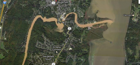
Above: A satellite image of the turbid lower Esopus spilling into the Hudson River. From Google Maps.
The following letter, from New York City Department of Environmental Protection (DEP) deputy commissioner Paul Rush, lays out the agency's reasoning behind the recent releases of turbid water from the Ashokan Reservoir into the Ashokan Release Channel.
A little background:
The DEP's use of the Ashokan Release Channel -- to reduce turbidity in the reservoir, and to let excess water out that might otherwise cause flooding downstream -- has been controversial since 2008, when the agency reactivated it after long disuse.
Releasing turbid water from the Ashokan is one of two main tools currently used by the DEP to reduce turbidity after heavy flooding in the Catskill-Delaware water system. The other is the use of a chemical called alum in the Kensico Reservoir, which forces sediment to settle out of the water, but comes with its own environmental costs.
Ulster County executive Mike Hein has been publicly campaigning against the DEP for various actions in the city's upstate watershed, including the use of the channel, which feeds into the Lower Esopus. Last month, Hein urged the state Department of Environmental Conservation to take action against the DEP for polluting the Lower Esopus. And earlier this week, Hein made headlines in downstate papers by calling the DEP an "occupying nation" in an open letter to city mayor Mike Bloomberg.
Without further ado: Paul Rush's open letter to watershed residents. --Ed.
Why We Operate the Ashokan Release Channel
We all want clear water, whether in the region’s streams or in our reservoirs—this is a critical concern of the New York City Department of Environmental Protection. Although there are limits on what can be done, in trying to meet this goal we try to find the right balance between water quality and flood protection.
The background to our current operations is that reservoirs throughout the city’s water supply have been filled to the brim after back-to-back record-breaking storms this summer and a wet fall. Typically at this time of year our reservoirs are 77% full – now they are at 96% capacity. Following Hurricane Irene and Tropical Storm Lee, we were concerned that downstream towns would be at risk of major flooding if immediate steps weren’t taken to reduce the level of the Ashokan Reservoir, which right now is at about 93% full. In addition, the wet year has mobilized silt and clay from both streambeds and the steep slopes in the region, causing many streams to run turbid; that turbid water is now in Ashokan Reservoir. As a result, DEC issued an Interim Protocol to reduce flood potential downstream of Ashokan Reservoir and ensure that water supply needs are met, while at the same time establishing objective turbidity limits for the first time. DEP has also committed to completing a public environmental review of the impacts and has even offered to pay for a technical expert to assist the Ashokan Release Channel Working Group.
Option 1: Stop Use of the Release Channel or Limit to 10-50 Million Gallons Per Day (MGD).
If DEP were to completely or effectively discontinue the use of the release channel today, which has been running at 600 MGD, then inflow from the watershed would quickly fill up both basins of the reservoir and turbid water would be spilled into the lower Esopus from the East Basin spillway in the Town of Marbletown. This would provide significantly less flood protection and still send turbid water into the lower Esopus. Such levels of turbidity throughout the reservoir would also continue to cause DEP to minimize water supply withdrawals, keeping reservoir levels unnecessarily high.
Option 2: Release From Only the East Basin.
The East Basin is slightly less turbid than the West Basin though both are visually cloudy. This means that any release from either basin right now will not be clear. And, after only a few days, the West Basin would almost immediately fill to capacity and spill into the East Basin—at precisely the location where the Release Channel and the Catskill Aqueduct take their water from. This would mean continued turbid water release through the channel and higher turbidity source water provided to High Falls, New Paltz, New Windsor, and nine million other residents of the state. That, in turn, means increases in treatment costs and chemicals that would have to be passed along to consumers.
Option 3: Continue with the Interim Protocol and Look to Improve It.
Releases from the West Basin are currently the only real way to create a void in the reservoir to protect downstream towns like Hurley and Ulster from future storms without increasing drinking water turbidity. Since the protocol was never envisioned to be permanent, we look forward to working with DEC and local stakeholders to review and improve it.
In an ideal world, there would be just enough rain to keep reservoir supplies up, but not enough to cause flooding concerns or stir up turbidity. But Mother Nature dealt us a different hand that offers no perfect answer.
In the meantime we believe the Interim Protocol protects downstream communities and strikes the right balance between flood protection and drinking water needs.
Paul Rush
Deputy Commissioner for Water Supply
New York City Department of Environmental Protection


