


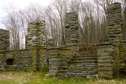
Above: The ruins of the Overlook Mountain House. Photo by Alan Via.
Trees growing in the ballroom? Porcupine teeth marks on the fuselage? In addition to scenic views and cascading waterfalls, many Catskills trails and roadways boast abandoned ruins and wrecks of times past. Hike, bike or drive past some of the more accessible abandoned places.
1. OVERLOOK MOUNTAIN HOUSE
The remains of the Overlook Mountain House on a Woodstock mountaintop offer dramatic photo opportunities. Two previous hotels occupied the site; both were destroyed by fire. Rebuilt in its concrete form, it was never completed. From Woodstock, take Route 212 to Rock City Road. Continue through the intersection. Mead’s Meadow Parking Area is two miles on the right. Hike 1.6 miles to the ruin. Note that the trail is extremely popular and parking is limited. If the parking area is full, try again in an hour or so. Be sure to carpool; leave additional vehicles in the municipal lot on Rock City Road.
Above: The stone foundations of Coykendall Lodge. Photo by Rebecca Andre.
2. ALDER LAKE AND COYKENDALL LODGE
Samuel D. Coykendall, railroad magnate, built the lodge and Alder Lake in 1899. The stone foundations of the lodge and some outbuildings remain. From Livingston Manor, turn right from Old Route 17 onto Beaverkill Road. Continue 12 miles. Turn left onto Alder Road Continue 2.2 miles; enter through the gate on the left. The ruins are on the left, immediately past the parking area.
3. STOPPEL POINT PLANE CRASH
Hiking to Stoppel Point on the Escarpment Trail, you can’t miss the 1983 wreck of a small private plane. It’s a long and challenging hike, so plan for a full day’s outing. Turn onto Route 18 from Route 23A in Haines Falls. Turn right on Schutt Road; right again into the parking area. Walk up Schutt Road and across Route 18 to find the Rock Shelter Trail. Follow to the Escarpment Trail (approximately two miles). 7.5 miles round trip.
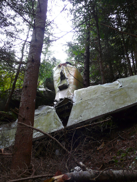
Above: The wreckage of a cargo plane on Kaaterskill High Peak. Photo by Heather Rolland.
4. KAATERSKILL HIGH PEAK PLANE CRASH
Chunks of the wreckage of a cargo plane, downed in 1987, sit right on the snowmobile trail. Take Route 23A in Tannersville to Route 16. Continue to parking area on the left. Hike the Long Path approximately three miles to the trail junction. Turn left onto the short connector trail and left again (heading south) onto the snowmobile trail. The cargo plane crash is one mile ahead.
5. THE BLIND LADY’S HOUSE—ASHOKAN HIGH POINT
Tucked away in the Kanape Valley, the stone walls of a blind hermit’s home still stand. Take Route 28 to Route 28A in Boiceville. Turn right onto Watson Hollow Road in West Shokan. Continue 4.1 miles. The parking area is on the right; the Kanape Brook Trail is across the road. Hike approximately one mile up the trail and look for an overgrown woods road on the left. Follow to the ruin.
6. CAIRN FIELDS—HALCOTT AND ASHOKAN HIGH POINT
Ancient stone piles, believed to be 3,000 years old, are found in large groupings on these two mountains. Halcott: Take Route 42 north from Shandaken. Continue five miles to the parking area on the left. Hike the unmarked path next to Bushnellsville Falls uphill and cross the creek. Continue south on an unmarked trail for approximately 0.25 miles. The cairns are scattered in this area. Ashokan High Point: Use driving directions above. Hike the Kanape Brook Trail 1.5 miles; scan the woods on your left. The cairn field is large and visible from the trail.
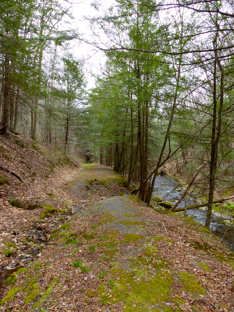
Above: A view of abandoned Russell Brook Road. Photo by Heather Rolland.
7. ABANDONED ROADWAY—RUSSELL BROOK ROAD
Marvel at the destructive power of water. Russell Brook Road was abandoned after repeated damage from floods. Take Route 206 north from Roscoe. Turn left onto Morton Hill Road. Continue 3.1 miles to make a left onto Russell Brook Road. Continue 0.5 miles to the parking area. Hike on the road, continuing past the trails on your right. Continue walking past the barrier. Be aware: Some places may be impassable after rain.
8. ABANDONED SKI AREA—BEARPEN MOUNTAIN
Scattered about the summit of Bearpen Mountain, you’ll find several rusting vehicles and some tow rope equipment from Bearpen’s old ski area days. From Prattsville, follow Route 2 for five miles. Turn right onto Route 3. Continue until pavement ends. Park off the roadway and hike up to the cabin. Turn right and follow the snowmobile trail to the summit.
9. ROCHESTER ESTATE RUINS
Stroll along a babbling brook to the ruined foundations of the Rochester Estate. Take Route 28 in Big Indian to Matyas Road. Park at the end of the road. Ruins are three miles up the trail.
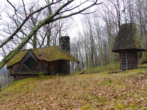
Above: The moss-covered "Grinch House" and a peculiar outbuilding. Photo by Heather Rolland.
10. THE GRINCH HOUSE
Saplings poke through the mossy-covered decaying roof of this fascinating structure. From Roxbury, take Vega Mountain Road 0.3 miles to turn left onto Ken Johnson Road. Make immediate left between stone walls and park where gravel ends. Walk up through the field, following an unmarked trail for 1.1 miles.

Above: An abandoned house on Lundy Road. Photo by Heather Rolland.
11. LUNDY ROAD
A ghost town that is a perfect spot for beginner mountain-biking adventures. Check out the abandoned structures along the seven-mile stretch of road. From Kingston, take Route 209 south to Wawarsing. Turn right onto Lundy Road. Park on the right after 0.7 miles. Ride to the end of the road and back.

Above: The gatehouse to Grossinger's in 2015. The golf course is still active. Photo by Acroterion, via Wikimedia Commons. By Acroterion - Own work, CC BY-SA 3.0.
12. GROSSINGER’S CATSKILL RESORT
This abandoned Borscht Belt resort is decaying magnificently—but it’s private property. Head to the still-active golf course and play a round, marveling at the ruins on your drive in. From Liberty, take Route 52 to Grossinger Road.
This article originally appeared in the print version of the 2016 Catskills Outdoor Guide, our annual publication about the Catskills outdoors. The Catskills Outdoor Guide is distributed across the Catskills region and at select locations in the NYC metropolitan area. Find a copy near you here.


