


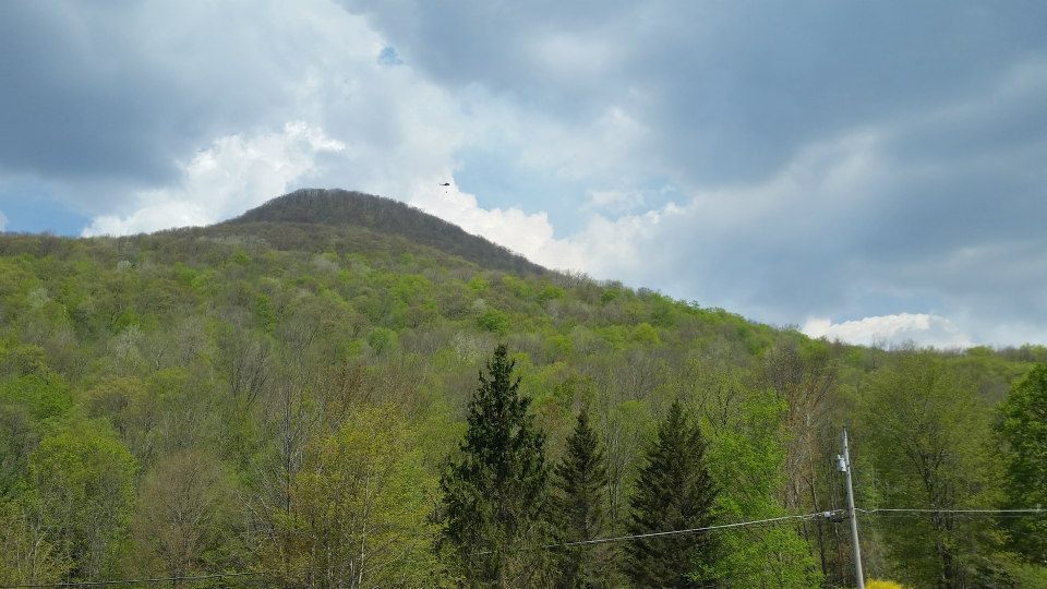
Above: Fire on the mountain. A helicopter pours water on a forest fire, visible as a plume of white smoke rising over the ridge, on Hunter Mountain on May 8, the second day of the blaze. Photo by Douglas Senterman.
Updates at bottom of post. -- Ed.
forest fire lanesville. heavenly valley road.
Posted by Leon Taufield on Thursday, May 7, 2015
Above: A photo of the fire burning on the southwest slope of Hunter Mountain in Lanesville on May 7, posted on Facebook by Leon Taufield.
A fast-moving brush fire burned anywhere from 50 to over 200 acres on the south slope of Hunter Mountain in the Greene County hamlet of Lanesville on Thursday, May 7, according to Greene County 911 officials and eyewitness reports.
The fire was reported to Greene County officials at 12:35 p.m., a 911 official told the Watershed Post this evening. At 4 p.m., the county received a report that over 200 acres of forest were ablaze, he said. There is no official information about how many acres are on fire this evening, and other sources are quoting lower acreage figures.
“Basically every fire department in the county, and some from outside, are there,” the Greene County 911 official said.
Official reports of the fire are sketchy, he said, because there there is no cell phone service in the area where the fire is burning, a remote valley in the town of Hunter on the opposite side of Hunter Mountain from the Hunter Mountain Ski Resort. Route 214 runs through the valley south from the rugged Stony Clove Notch.
Above: A photo of Stony Clove Notch, the area where the forest fire is burning, taken by Sean Mahoney at dusk on May 7.
The fire began on Heavenly Valley Road off Route 214 in Lanesville, and a command post has been set up at the Lanesville Fire Department. There is no word yet on what caused the fire.
The 911 official could not confirm reports that helicopters are battling the blaze with Bambi buckets, which dump water on a fire from above.
Douglas Senterman, a resident of Platte Clove, saw two helicopters in the area around Route 214 on Thursday, May 7. Videos from several witnesses, including a reporter at WNYT, back that up.
HD... fire
Posted by Leon Taufield on Thursday, May 7, 2015
Above: Leon Taufield posted a video of helicopters dumping water on a brush fire on Hunter Mountain on May 7.
“The backside slope of southwest Hunter Mountain is burning,” Senterman said. “And it's going upslope.”
Senterman said that smoke was in the air in the town of Hunter north and west of the fire, near Carr Road, and that Route 214 was closed at the intersection of of Route 23A, near the village of Hunter.
Panicked residents of Lanesville spent the afternoon worrying about their property. One woman, a Lanesville resident, told the Watershed Post that the fire was two miles away from her house.
Update, Friday, May 8, 9:30 a.m.: There are no new official details on the fire's spread, but photos and reports are emerging from last night. Hunter's Fire Company Number 1 posted photos from the scene yesterday:
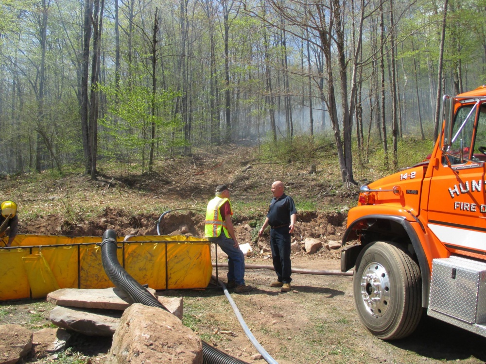
Above: "Hunter 14-2 pumping water uphill into the fire area above us. It had already passed by from the left to the right." Hunter firefighters at the scene of a brush fire in Lanesville on May 7, from a post by Hunter Fire Company No. 1 on its Facebook page.
A reporter from Time Warner Cable News had the best information from the fire yesterday. She talked to firefighters and to Greene County Director of Emergency Services John Farrel, who was at the scene late into the night. Farrel told the network that firefighters stopped actively fighting the blaze after dark and were planning to begin again at 8 a.m. this morning.
Leon Taufield of Lanesville posted another photo of smoke in the valley at 6 a.m. this morning on his Facebook page:
6am mountain in Lanesville still smokey Fire Fighters starting to gather again. I here planes may be coming to the area to drop chemicals around 8am
Posted by Leon Taufield on Friday, May 8, 2015
Update, Friday, May 8, 11 a.m.: Greene County Emergency officials and firefighters at Lanesville staging area say they are not releasing information this morning.
Official sources from other agencies involved in fighting the fire tell the Watershed Post that the Lanesville fire is still burning, and that the number of acres on fire is probably less than 100 acres -- a lower number than the 200-acre figure that first responders first released yesterday.
"It seems to be in the 50 to 100 acre range," said New York City Department of Environmental Protection spokesman Adam Bosch, whose agency is involved in fighting the blaze. "I know that's a wide range, but I think everyone agrees on that."
A fixed-wing “Fire Boss” air tanker from Canada, which was used by first responders earlier this week to fight the fire in the Shawangunk Ridge State Forest, has been pressed into service to dump water on the Lanesville fire, Bosch said. Helicopters carrying water-bearing Bambi buckets are also gathering water from ponds in the Lanesville area to douse the fire, he said.
The "Fire Boss" airplane can scoop up to 800 gallons of water from a water body while flying and then dump its payload on a fire. Today, the plane is gathering water from the DEP's Schoharie Reservoir, one of the sources of New York City's water. By 11 a.m., it had already made several trips to drop water on the Lanesville fire, Bosch said.
The airplane is flying out of the Orange County Airport in Montgomery, New York, where a crew of DEP engineers steam-cleaned it before allowing it to gather water from the Schoharie Reservoir, Bosch said.

Above: DEP staffers steam cleaning the "Fire Boss" fixed-wing airplane at the Orange County Airport on May 7 to prepare it for gathering water from the Schoharie Reservoir to fight the Lanesvile fire. Photo courtesy of NYC DEP.
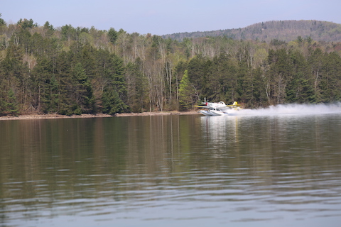
Above: The "Fire Boss" taking off with a payload of water from the Schoharie Reservoir. Photo courtesy of NYC DEP.
Rick Georgeson, a spokesman for the New York State Department of Conservation, which oversees the forest rangers who are fighting the fire, said today that fire departments from Hunter, Haines Falls, Lanesville, Tannersville, Phoenicia, Palenville, Catskill, Cairo, Windham and Grand Gorge have responded to the Lanesville blaze.
Update: Friday, May 8, 9:50 p.m.: Although the Lanesville fire has been burning for over 24 hours, information about how many acres have burned and how much of the fire is contained is hard to come by and conflicting.
Once again, Time Warner Cable has the only information from officials at the scene, who are very difficult to reach by phone. The network reports that about 100 acres have burned.
Gov. Andrew Cuomo issued a press release this afternoon stating that the Lanesville fire had burned 60 acres and was 30 percent contained. The release also stated that a variety of state resources are on the scene:
In Greene County, personnel from the Department of Environmental Conservation, State Police, Office of Fire Prevention and Control, Office of Emergency Management, and Office of Interoperable Emergency Communications are assisting local first responders with command and control support. The fire is currently 30 percent contained and is difficult to battle due to the mountainous terrain and dense forest.
An unamed official who has spent time fighting the fire in Hunter this week said that the blaze was the largest brush fire in the town of Hunter in recent memory.
Helicopters dropped water on the fire throughout Friday, May 8, according to Doug Senterman, who shot photos of the blaze and sent the Watershed Post reports from the scene. Senterman said that the fire appears to have moved higher up the mountain.

Above: A helicopter took off with a payload of water to douse the fire on May 8. Photo by Doug Senterman.
Above: Smoke rises from the fire on Hunter Mountain on May 8. Photo by Doug Senterman.
Hiking trails in the Hunter-West Kill Wilderness Area are closed due to the forest fire, and campfires are completely banned in the Catskill Park until May 14 to prevent more blazes, the DEC and the governor ordered today.
The trails that are closed are the Devil’s Path Trail, the Diamond Notch Trail, Beckner Hollow Trail, Hunter Mountain Trail, Spruceton Trail and the Colonel’s Chair Trail.
Volunteers posted signs at the trailheads in Hunter warning hikers of the fire danger and the trail closures.
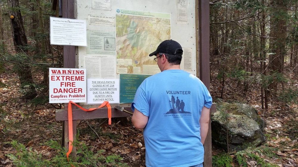
Above: A volunteer posts signs at Hunter hiking trails, which are closed due to the forest fire. Photo by Douglas Senterman.
Update: Sunday, May 10: We finally got through to officials at the scene of the fire, who told the Watershed Post at noon on Sunday, May 10 that firefighters and forest rangers contained the fire at dusk on Saturday, May 9. Today, the fire is still contained, officials said. Read our full update in a separate story by clicking here.


