


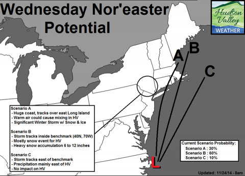
Above: Hudson Valley Weather's analysis of the impact of a nor'easter on Wednesday, Nov. 26. Via the Hudson Valley Weather Facebook page.
The forecast for the next 48 hours is looking decidedly weird.
Today's temperatures are breaking records for warmth. According to the National Weather Service, at 1 p.m., the high in Poughkeepsie was 69 degrees, the highest temperature ever recorded on Nov. 24 in that city since recordkeeping began in 1948. (The last record was 68 degrees in 1979.)
At the same time, a nor'easter is on track to wallop the Atlantic coast on Wednesday, Nov. 26: the high-travel day before Thanksgiving. All of the Catskills are under a winter storm watch from 7 a.m. Wednesday morning through Thursday morning.
Hudson Valley Weather is on high alert, and is warning anyone with travel plans to think twice before heading out on Wednesday:
Our preliminary concern is that 6 to 12 inches of snow is possible for a good portion of the Hudson Valley… with some locally higher amounts. Those with travel plans Wednesday afternoon should begin to consider backup options. The preliminary timeline appears to be from 12pm Wednesday thru the pre-dawn hours on Thanksgiving.
This is a lot of freakish weather. Can anyone blame our nation's forecasters for having trouble predicting it?
Gov. Andrew Cuomo can. In remarks about the seven feet of snow that paralyzed the city of Buffalo last week, Cuomo seemed to point the finger at meteorologists, according to Celeste Katz at the New York Daily News:
"No one had an idea that it was going to be that much snow, that fast,” Cuomo said on Saturday. “Snow coming down at the rate of about five inches per hour. No one had an idea. The weather service was off, by the way, which is why I said in my State of the State last year, we’re putting in our own weather detection system.”


